
Fforest Fawr
Geopark
A guide to exploring the western half of the
Brecon Beacons National Park.
www.fforestfawrgeopark.org.uk

Great days out in
Fforest Fawr
Geopark
Planning to spend some time
in the Geopark?
Here are some suggestions for places to
visit, things to see and do to make your
visit to the Geopark, the western half of
the Brecon Beacons National Park, both
enjoyable and memorable. We’ve
arranged them to help you choose
depending on the time available to you
- perhaps you’re looking to spend a half
or full day, then again maybe you’ve
only got an hour to spare.
Of course, you can extend or shorten
your visit to suit yourself. These and other
stories - history, archaeology, myths,
wildlife - are told through Geotrails and
other walk leaflets, exhibitions, audio trails
and panels around the area. Also look
out for individual events organised
throughout the year by Fforest Fawr
Geopark, particularly during the annual
Fforest Fawr Geopark Festival in late
May/early June.
To dig deeper, visit the website at
www.fforestfawrgeopark.org.uk
Key to icons used in guide
6 figure OS grid reference of site entrance
Sat Nav-friendly postcode
Telephone number
Relevant website
Getting there
Many attractions in this rural area are not on a bus
route and remote from the rail network. Taxi services
operate throughout the area - for more info go to:
www.breconbeacons.org/getting-around or put in a
postcode at
www.traveline-cymru.info
Nearest regular bus route
and distance by road
Free car parking
Pay & display parking
Facilities
What can I expect when I get there? Please be
aware that not all facilities are open seven days
a week and some may be closed or have more
restricted opening times during winter months.
Also remember that details of attractions can
change – it’s always best to check on the web, by
phone or ask at an information centre before you go.
Site admission charge payable
Free entry to attraction
Nearest railway station
and distance by road
You can also get the times of the next buses
from any stop at nextbuses.mobi or download
the app
www.fforestfawrgeopark.org.uk
Toilet facilities available
Site/trail leaflet or audio trail available
Café/restaurant/tea rooms at site
Picnicking facilities available
Site with archaeological/historical interest
Site with industrial archaeology interest
Nature reserve or other key wildlife site
Wet weather suggestion
If you are looking for an introduction to the
rocks, then pick up the general leaflet. For
further detail, browse the shelves of the
information centres across the Geopark
- there’s something for all including the
official 1:50,000 geological map of Fforest
Fawr Geopark – published by the British
Geological Survey in 2014.
Did you know?
An increasing number of local people
running tourism businesses in this area
are National Park Ambassadors and
Geopark Ambassadors. Committed to
ensuring that visitors get the best from
their stay, they are trained and
knowledgeable about the Geopark.
www.breconbeacons.org/ambassadors
The Geopark after dark
Brecon Beacons National Park was
declared Wales’ first International Dark
Sky Reserve in 2013 - and some of the
darkest skies are in Fforest Fawr Geopark.
There are regular stargazing events
organised to help you enjoy our most
distant views – many hosted by our
Dark Skies Ambassadors.
www.breconbeacons.org/stargazing
This is a landscape shaped by rock
Please remember that you don’t need any special
geological knowledge to enjoy this place. Though
Geoparks are areas with amazing geology, they’re not
just about rocks, as this guide shows. However, look out
for these icons which provide clues to what you’ll see:
Geological interest - under your feet is a layer
cake of rocks
Karst landscapes produced as limestone rock
dissolves to produce caves, limestone
pavements sinkholes and springs
Geological faults & folds some of these rocks
are fractured and crumpled!
Ice Age legacy - glaciers sculpted this land
during a series of ice ages
Mining /quarrying interest - people have quarried
mineral riches here for hundreds of years

Ffairfach
Grit
used to construct
Garn Goch
hillfort
Carreg Cennen Castle
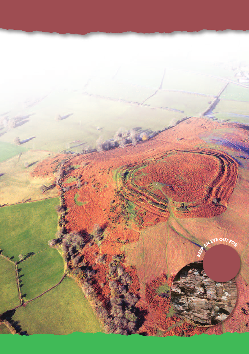
1. Castles and Crags
Carreg Cennen Castle and Garn Goch Iron Age hillfort
Visit spectacular Carreg Cennen Castle near Llandeilo. Perched atop a 100m
high sheer limestone crag overlooking the Afon Cennen, this mediaeval fortress
with a long and chequered history is now in the care of Cadw. Enjoy the tea rooms
and craft shop at the farm before making the short walk to the castle ruins.
Down the road (or along the Beacons Way) is Y Gaer Fawr, largest hill-fort in South
Wales and one of two at Garn Goch overlooking the hamlet of Bethlehem. Once a
stronghold of the Silures tribe who chose it perhaps for its commanding views over the
Towy valley, it now rewards an hour or two of your time spent in exploration. Pick up the
Garn Goch Geotrail (£1) at Llandovery Information Centre. The Red Kite feeding station
and the National Trust’s Dinefwr Park, Newton House and Castle are nearby attractions.

To find out more about local public transport go to www.traveline-cymru.info
Carreg Cennen Castle
SN 668191 SA19 6UA
SN 682243
SA19 6YW
01558 822291
www.carregcennencastle.com
If you've got an hour or less:
Tea and cake at Castle tearooms
SN 652188
Explore Garn Goch
follow the whole Geotrail if you’ve time
SN 733186
If you've got a full day (6-8 hours):
Walk the first section of the Beacons Way
from Bethlehem to the historic Black Mountain
quarries.
(Heart of Wales Line) Ffairfach, Llandeilo 3.7/4.5miles
Trap Village Hall and café
01558 823213
If you've got half a day (2-4 hours):
A visit to Carreg Cennen Castle
and woods
SN 625225
SA19 6RT
Explore historic Llandeilo
Castle and Newton House
01558 824512
www.nationaltrust.org.uk/dinefwr
www.breconbeacons.org/blackmountainquarries
SA19 6TR
Getting there
www.trapvillagehall.com
Did you know?
Carreg Cennen Castle has been
described as the most romantic in
all of Wales
Visit Dinefwr Park

Garwnant Visitor Centre
crumbling
mudstone
in stream
banks
© Crown copyright
2. Water and Woodlands, Tracks and Trains
Garwnant Forest and Visitor Centre, Taf Fechan Forest
Just off the A470, Garwnant Visitor Centre has information, outdoor play for children
and a restaurant. Follow one of the woodland walks, some with a ‘geo’ theme.
For walkers the Taff Trail runs up Cwm Taf past the centre and a separate route for
cyclists follows the old railway from Cefn-coed-y-cymer up Cwm Taf Fechan then
through the forest.
The top end of the Taf Fechan is a good starting point for longer walks in the central
Beacons. The less energetic can enjoy a ride on the Brecon Mountain Railway near
Pontsticill. The railway and nearby Cyfarthfa Park, Castle, Museum and Art Gallery are
also good family friendly places to visit if the rain starts to fall!

To find out more about local public transport go to www.traveline-cymru.info
Garwnant Visitor Centre
SO 003132
01685 722481
www.facebook.com/GarwnantVisitorCentre
If you've got an hour or less:
The sculpture trail from Garwnant
Merthyr Tydfil (5 miles)
Getting there
SN 952084 CF44 9JW
01685 810650
A tour of Penderyn Welsh Whisky Distillery
www.welsh-whisky.co.uk
Food and drink at Garwnant restaurant
If you've got half a day (2-4 hours):
Walk or cycle one of the longer forest trails
If you've got a full day (6-8 hours):
Walk or cycle a section of the Taff Trail
SO 059097 CF48 2UP
Take a ride on the Brecon Mountain Railway
01685 722988
www.breconmountainrailway.co.uk
www.breconbeacons.org/tafftrail
SO 042074 CF47 8PA
Cyfarthfa Park, Castle, Museum & Art Gallery
01685 727371
www.cyfarthfa.com
T4
CF48 2HU
Search for ‘Taff Trail at www.breconbeacons.org
Did you know?
The Taff Trail stretches all the way
to Cardiff and is 55 miles / 88km long.

Penwyllt and Fan Gyhirych from Cribarth
3. Caves and Kilns: delving into the wild
Craig-y-nos Country Park and Penwyllt
Start your exploration of the upper Swansea Valley/Cwm Tawe with a visit to
Craig-y-nos Country Park.
Soak up the atmosphere at Penwyllt where abandoned tramways, limekilns and an old
fire-brickworks sit beside the Ogof Ffynnon Ddu National Nature Reserve. The reserve
protects limestone pavements above ground and Britain’s deepest cave (308m) below.
The Beacons Way passes through here en route from the wild and remote Black
Mountain to the highly distinctive hills of Fforest Fawr. Closer at hand is the rocky ridge
of Cribarth with its limestone crags, old quarries and tramroads.
plant fossils
in the
Twrch
Sandstone

To find out more about local public transport go to www.traveline-cymru.info
SN 855155 SA9 1GQ
If you've got a full day (6-8 hours):
If you've got half a day (2-4 hours):
Follow the Penwyllt walk card from the country
park. Listen to the podcast
Follow the Beacons Way east from Penwyllt
through Ogof Ffynnon Ddu NNR
Listen to the podcast as you walk to Waun
Fignen Felen
SN 855155
SA9 1GQ
Craig-y-nos Country Park
SN 840155
01639 730395
www.breconbeacons.org
If you've got an hour or less:
Enjoy the Café, play area and a walk around
the country park
Neath (15.5miles)
Getting there
Short walk into the national nature reserve using
the old Brecon Forest Tramroad
SN 853120 SA10 9PG
Follow the Henrhyd Falls Geotrail
down to the Tawe or follow the ‘Lines in the
Landscape’ walk along Sarn Helen
and old tramways
Explore Cribarth, very interesting limestone mountain
SA9 1GL
www.breconbeacons.org/ogof-ffynnon-ddu-nnr
www.breconbeacons.org/audiotrails
www.breconbeacons.org/audiotrails
Did you know?
Nineteenth century opera singer
Adelina Patti lived at Craig-y-nos
– she was perhaps the first
global superstar - the Lady
Gaga of her day!
www.breconbeacons.org/ogof-ffynnon-ddu-nnr
X63 ar hyd yr A4067

Llandovery
4. Land of legends
Llandovery & Myddfai
Visit the Mid Wales market town of Llandovery in the Towy Valley
where Welsh princes and drovers are celebrated.
Seek out the traditional Carmarthenshire village of Myddfai
where you can enjoy tea and cake at the community hall
and visitor centre and learn about the legend of the Lady
of the Lake and the Physicians of Myddfai. Then take to the
Old Red Sandstone hills to the south or follow in the
footsteps of Romans and tilestone-quarrymen across
Mynydd Myddfai. Bring a bike or hire one locally to explore
this culturally rich corner of the Geopark.
ripple-marked
Silurian
sandstones
Did you know?
The ‘Llandovery Epoch’ is a term used by geologists all around the world when
talking of geological events 440 million years ago – whether in Wales, China
or Peru!

SN 772301 SA20 0JD
www.myddfai.org
Follow the Llandovery building stones Geotrail
If you've got a full day (6-8 hours):
SN 820271 LD3 8YD
Cycle the Usk Reservoir Loop from Pont a’r Wysg
01550 720449
Visit the Tourist Info & Heritage Centre
SN 772260 SA19 9YG
www.redkiteswales.co.uk
Red Kite feeding station, Llanddeusant
01550 740617
A walk on Mynydd Myddfai
Visit shops and cafes
in Llandovery
SN 845300
Explore the Roman camps at Y Pigwn
SN 763345 SA20 0BG
www.heart-of-wales.co.uk
Take a trip by train along the Heart of Wales Line
01554 820586
SN 799238
Cycle the quiet lanes past Llanddeusant then
walk up to magical Llyn y Fan Fach – moraines
& myths aplenty
SA19 9UN
To find out more about local public transport go to www.traveline-cymru.info
If you've got half a day (2-4 hours):
Llandovery Tourist Information Centre
SN 767343
01550 720693
www.breconbeacons.org
If you've got an hour or less:
Tea and cake at Myddfai Visitor Centre
Llandovery, (Heart of Wales Line), (0.3mi)
Getting there
SA20 0AW
www.breconbeacons.org/audiotrails

Sgwd Gwladus on Afon Pyrddin
5. Waterfall Country - Falls, Ferns & Faults
Pontneddfechan, Ystradfellte and Coelbren
Start your visit to Waterfall Country by calling in at the Waterfalls
Centre at the heart of Pontneddfechan - enjoy the Geopark
exhibition and pick up all the information you need to
enjoy and understand the area.
Here you will find more spectacular waterfalls to the mile
than on any other group of rivers in the UK - what better
place to visit in sunshine - or in rain!? Enjoy the 45 minute
walk beside the Nedd Fechan and Pyrddin rivers to Sgwd
Gwladus then return to the village for a pub lunch. The car
park beneath Dinas Rock is only a five minute drive to the end of
the road from the Waterfalls Centre. Here former tramways provide excellent walking
routes between the abandoned limestone and silica rock workings and through the
nearby Gunpowder Works, once bustling but quiet since 1931. Enjoy the walk to Sgwd yr
Eira and walk behind the falls if you’ve a half day to spare - either from Dinas Rock or
from Gwaun Hepste. Pick up a copy of the Waterfall Country pack from the Waterfalls
Centre.
Pennant
Sandstone
paving flags
from the Coal
Measures

Food and drink in Pontneddfechan
or Ystradfellte.
To find out more about local public transport go to www.traveline-cymru.info
Half a day (2-4 hours):
Waterfalls Centre
SN 901076
01639 721795
www.breconbeacons.org
X5
If you've got an hour or less:
Introduction to the Geopark at the
Waterfalls Centre. Opening times vary by season
Neath (13miles)
Getting there
Full day (6-8 hours):
Visit the NT’s Henrhyd Falls at Coelbren
see section 3
SN 897068 SA11 5LU
Walk the Cwm Gwrelych trail
Short walk beside the Sychryd to the folded
limestone crag of Bwa Maen
SN 924192
Visit Maen Llia, Bronze Age standing stone
Tour of Penderyn Distillery
- see section 2.
SN 928124
At Cwm Porth, pick your way down to Porth yr
Ogof, Wales largest cave entrance where the
Mellte river disappears underground for ¼ mile
CF44 9JF
Use wind-up audio points to explore
the Gunpowder Works
Follow the audio trails, walking up the Nedd
Fechan and Pyrddin to view the falls
Combine various walks to visit all of the falls
on a round tour from Gwaun Hepste
SA11 5NR
Did you know?
The Russian word for firebrick is ‘Dinas’, as the silica
rock once quarried here at Dinas Rock was formed
into firebricks and sought after worldwide.
Pen-y-crug hillfort outside Brecon
6. Historic Brecon - rivers and ramparts
Cathedral, canal, hillfort, Honddu and Usk
Begin your visit at the Brecon Tourist Information Centre - three Geotrails lead from
here - walk along the Usk and up the Honddu rivers for waterside views or head for
Pen y crug for a panoramic view from the Usk valley to the Brecon Beacons.
Stay in town for shopping and visits to the cathedral, museums, cafes and shops.
There are also canoeing and boating opportunities on the canal and river.
Old Red
Sandstone
quarries
source of the
town’s building
stone
©Hawlfraint CPAT
Did you know?
Longest canal in Wales, the ‘Mons & Breck’ Canal
celebrated its 200th birthday in 2012.

To find out more about local public transport go to www.traveline-cymru.info
If you've got half a day (2-4 hours):
Brecon Tourist Information Centre
SO 046287
01874 622485
www.breconbeacons.org
T4, X63
If you've got an hour or less:
Brecon Cathedral and heritage centre
Abergavenny (21m to E), Merthyr Tydfil (19.3m to S) or Llandovery (21m to W)
Getting there
If you've got a full day (6-8 hours):
Walk or cycle the Monmouthshire and Brecon
Canal towpath from the theatre basin to Brynich
Lock or even Talybont
SO 046282 LD3 8LE
Shopping, eating, sightseeing in Brecon
SO 044290
LD3 9DP
Follow the Pen-y-crug or Brecon River Usk
and Brecon town Geotrails
Down on the canal, take a boat-trip
or a Canadian canoe trip
0800 6122890
Follow the Pen y Fan and Cribyn walk card up
onto the central Beacons from the National Trust’s
Cwm Gwdi car park
SO 025248
LD3 8LE
01874 623857
www.breconcathedral.org.uk
SO 049283
LD3 7EB
01874 613310
SO 037289
LD3 9AY
01874 622995
www.royalwelsh.org.uk
Regimental Museum
Rowing on the River Usk at Brecon prom
SO 046282
LD3 7EW
01874 622995
www.dragonfly-cruises.co.uk
www.beaconparkdayboats.co.uk
LD3 9DA

Limekiln at Herbert's Quarry
7. The Black Mountain - Earth’s riches
Black Mountain Centre & the Black Mountain Quarries
Start your day with a drink or a full breakfast at the Black Mountain Centre in
Brynaman then follow the mountain road to the old Black Mountain quarry
complex.
Enjoy extensive panoramic views west to Pembrokeshire, south to the Bristol Channel
and north to Plynlimon on clear days. Limestone, silica rock and silica sand were
quarried here until the 1950’s. Encounter Bronze Age cairns along the Beacons Way to
the east and west of the quarries or enjoy the more intimate - and sheltered - wooded
valleys on the Black Mountain’s southern fringe.
fractured
Carboniferous
Limestone
Did you know?
The Amman valley was a stronghold of the Welsh language when George Borrow
visited ‘Gwter Fawr’ (modern day Brynaman) in the 1840’s - and it remains so today.

To find out more about local public transport go to www.traveline-cymru.info
If you've got half a day (2-4 hours):
Black Mountain Centre, Brynaman
SN 713143
01269 823400
www.brynaman.org.uk
If you've got an hour or less:
Ammanford (7.5mi)
Getting there
If you've got a full day (6-8 hours):
Follow the Rocky Ravines trail from the Centre
Follow in the footsteps of Twrch Trwyth,
legendary wild boar, visiting sites mentioned
in The Mabinogion. Pick up a copy of the
Amman Valley walks and trail pack
SN 733188
SA19 9PE
www.breconbeacons.org/blackmountainquarries
Eating and drinking at the Black Mountain
Centre, Brynaman
Explore a section of the Beacons Way
from Black Mountain Quarries
Driving up the mountain road, enjoy the views
and explore the Black Mountain quarry complex
SN 750123
SA18 1DZ
Follow the trail 'From Cwm to Cwm' starting
at Garnant in the Amman Valley
www.aattt.org.uk
SA9 2YJ
Explore the more sheltered Henllys Vale from
Ystradowen using the Geotrail or audio trail
SA18 1BU
SN 686135
www.breconbeacons.org/audiotrails

Pen y Fan from Mynydd Illtud
8. Classic Beacons
Mynydd Illtud, Glyn Tarell and the National Park Visitor Centre
Pick up a Geotrail leaflet from the National Park Visitor Centre (‘the Mountain
Centre’) and enjoy a walk on the common at Mynydd Illtud. Return to the Visitor
Centre for lunch or a coffee.
Glyn Tarell with a view of the iconic skyline of Pen y Fan and Corn Du to the east and
the national nature reserve of Craig Cerrig-gleisiad and Fan Frynych to the west is only
a short drive away.
outcrops of
Old Red
Sandstone
Did you know?
Pen y Fan owes its flat top to a hard capping of Plateau Beds sandstone
– ripples in the bedrock betray its watery origins!

To find out more about local public transport go to www.traveline-cymru.info
If you've got half a day (2-4 hours):
National Park Visitor Centre
SN 977263
01874 623366
www.breconbeacons.org
T4
If you've got an hour or less:
Merthyr Tydfil (17.2mi), Llandovery (17.6mi), Abergavenny (26mi)
Getting there
SN 982203
LD3 8NL
Enjoy the shop, exhibition and tea room indoors
and the new children’s outdoor play area.
Take a longer walk on the common
eg Mynydd Illtud Geotrail
Take a walk on the common with
‘What to see from the NPVC’
Short walk to national nature reserve
at Craig Cerrig-gleisiad
If you've got a full day (6-8 hours):
Follow the Glyn Tarell Geotrail from here too, for
spectacular views onto the glacial and landslip
forms of Craig Cerrig-gleisiad!
Visit Brecon - shops, cafes, museums,
cathedral etc - see page 8
SN 982203
LD3 8NL
Follow a walk card to enjoy an ascent of Pen y
Fan from Storey Arms (not a pub!) or Pont ar Daf
LD3 8ER

5
3
7
1
Ffordd y Bannau
Pa ffordd well o ddod i
adnabod Geoparc y Fforest
Fawr na cherdded y llwybrau a
gefnogir gan Gymdeithas Parc
Bannau Brycheiniog ac
Awdurdod y Parc Cenedlaethol?
BRoedd tywysydd daearegol –
‘Land of the Beacons Way’ - a
gyhoeddwyd yn 2014. Ewch i
www.breconbeacons.org
/beacons-way
Mapiau
rhyngweithiol
Mae mwy o wybodaeth am
hanes, daeareg a bywyd gwyllt
yr ardal hon ar gael ar
www.geoparcyfforestfawr.org.uk
a cofiwch y gallwch ddefnyddio’r
mapiau rhyngweithiol ar
www.breconbeacons.org
wrth ddewis llwybr neu drip
fyddai’n addas ichi a’r teulu.
Taflenni llwybrau a
llwybrau llafar
Cyhoeddir 9 Geolwybr, 4 o
gardiau llwybrau, a nifer o
daflenni a llyfrau eraill am
lwybrau o fewn ardal y
Geoparc. Mae llawer ohonynt
ar gael am £1 yr un o
ganolfannau gwybodaeth ac
ymwelwyr y cylch.
Gellir lawr lwytho nifer o lwybrau
llafar a phodlediadau o’r wefan
ar www.geoparcyfforestfawr
.org.uk/llawrlwytho
Ewch i’r siop ar y we
www.beacons-npa.gov.uk
/shop
Map o Geoparc y Fforest Fawr
Cestyll a Chlogwyni
Dw
^
r a Choedwigoedd, Llwybrau a Threnau
Ogofâu ac Odynau
Bro Chwedlonol
Bro’r Sgydau
Tref Hanesyddol a’r cyffiniau
Y Mynydd Du - cyfoeth y ddaear
Y Bannau Clasurol
www.fforestfawrgeopark.org.uk
4
1
2
3
4
5
6
7
8

2
6
8
Beacons Way
What better way to explore
Fforest Fawr Geopark than to
walk the trail supported by the
Brecon Beacons Park Society
and National Park Authority.
A geological guide, ‘Land of
the Beacons Way’, was
published in 2014.
Visit www.breconbeacons.org/
beacons-way
Interactive mapping
There’s more on the history,
geology and wildlife of this
area at www.fforestfawr
geopark.org.uk and don’t
forget that you can use the
interactive mapping at
www.breconbeacons.org
to choose a walk or ride
suitable for you and your
family.
Trail leaflets
and audio trails
Nine Geotrails, four ‘walk
cards’ and a number of other
walks leaflets and books are
published for the Geopark
area. Many are available at
£1 each from information
and visitor centres in the area.
Several audio trails and
podcasts can be
downloaded from
www.breconbeacons.org/
audiotrails
Visit the Brecon Beacons
online shop at
www.beacons-npa.gov.uk/shop
- many new maps, books and
leaflets now in stock.
Map of the Geopark
Castles and Crags
Water and Woodlands, Tracks and Trains
Caves and Kilns – delving into the wild
Land of Legends
Waterfall Country – falls, ferns & faults
Historic Brecon – rivers and ramparts
The Black Mountain - Earth’s riches
Classic Beacons
www.geoparcyfforestfawr.org.uk
1
2
3
4
5
6
7
8
