
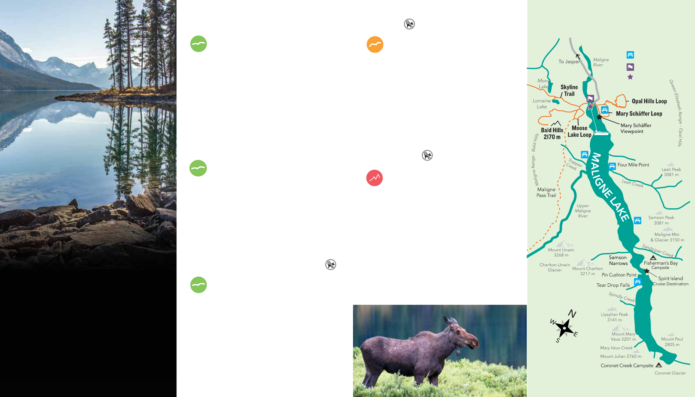
HIKING MAP
SERVICES: Maligne Lake Day Lodge, View Restaurant, Boat
Cruise ticket ofce, shopping, restrooms & telephone
BOATHOUSE: Boat rentals, shing gear & licences
TRAIL: Hiking trail
OLD TRAIL: No longer maintained
EMERGENCY: Jasper National Park Warden Station
P
PARKING: Two lots east and one lot west of the lake
PICNIC SITE: Picnic Point
HISTORIC BUILDING: Maligne Lake Chalet 1927,
Curly Phillips Boathouse 1928, Cottage 1935
MALIGNE LAKE OVERVIEW
P
3
P
2
P
1
MALIGNE LAKE
CRUISE & LUNCH
GET A TASTE OF THE CANADIAN WILDERNESS
Your journey takes you across vibrant blue waters in the
shadow of snow-capped peaks as you head toward the
beauty and seclusion of Spirit Island. Before or after the
experience, enjoy a gourmet buffet luncheon at Maligne
Lake Chalet. The historic 1927 chalet welcomes you with a
natural wood replace, locally sourced fare and stunning
views of pure Rocky Mountain magic in every direction.
AVAILABLE JULY 1 TO SEPT. 3. RESERVATIONS ARE ESSENTIAL.
VISIT MALIGNELAKE.COM FOR CURRENT PRICING.
BOAT CRUISE: Dock point for scenic lake cruise
BEST BOAT CRUISE
IN CANADA
Reader’s Digest
IN JASPER, VISIT 616 PATRICIA STREET.
CALL NOW TO BOOK YOUR CRUISE & LUNCH.
1.888.725.0232 | malignelake.com
FSC
LOGO
ROAM FREE AND
ENJOY THE TRAILS
Maligne Lake is an exceptional area for hiking.
With trails that vary from peaceful, short walks
in the woods to steep, steady uphill grinds, the
one thing they all have in common is amazing
scenery. So explore your way and when you’re
ready for a break, join us at the lake. Great dining
options let you relax, refuel and get back to the
trails or the water for a closer look at this
inspiring place.
MOOSE LAKE LOOP
EASY
|
2.6-KILOMETRE LOOP
ELEVATION GAIN – MINIMAL
TRAILHEAD – PARKING AREA 3 (P3)
Thousands of years ago, a half billion cubic metres of rock
fell from a ridge, blocking the valley and enlarging Maligne
Lake to its present size. This trail follows the forested valley
oor, offering fewer mountain views. Instead, your path
follows a fascinating landscape made up of hills, hollows
and mossy, lichen-encrusted boulders that dot the ancient
slide heap. After a short section of relatively level terrain, turn
left off the Maligne Pass Trail. Moose Lake lies in a hollow in
the rock slide debris.
MARY SCHÄFFER LOOP
EASY
|
3.2-KILOMETRE LOOP
ELEVATION GAIN – MINIMAL
TRAILHEAD – PARKING AREA 1 (P1)
This well-maintained trail starts by taking you past the
historic Curly Phillips Boathouse and Picnic Point, winding
along the northeast shore of the lake to the Mary Schäffer
Viewpoint at the entrance of Home Bay. Leaving the
shoreline, the trail passes through a subalpine forest of
spruce and r and past a collection of depressions (glacial
kettles). The trail then loops back to the Day Lodge. With
little elevation gain, this is an easy hike.
MONA & LORRAINE LAKES (SKYLINE TRAIL)
EASY
|
2 KILOMETRES ONE-WAY
ELEVATION GAIN – 100 METRES (330 FEET)
TRAILHEAD – PARKING AREA 3 (P3)
This is an easy hike through a lodgepole pine forest to two
small kettle lakes. The trail climbs gently for 2 kilometres,
at which point a short trail on the left leads to Lorraine Lake.
Back on the main trail, a short walk takes you to another
side trail on your right. This leads to Mona Lake and the
2-kilometre point. If you’d like to go farther, walk
2.4 kilometres along the main trail and arrive at Evelyn
Creek. At this point the trail becomes switchbacks, taking
you up to the treeline and Little Shovel Pass (at the
10.3-kilometre mark).
BALD HILLS
MODERATE | 5.2 KILOMETRES ONE-WAY
ELEVATION GAIN – 495 METRES (1,620 FEET)
TRAILHEAD – PARKING AREA 3 (P3)
This uphill journey, with an elevation gain of 495 metres,
is well worth the effort. The summit was once the site
of a re lookout station and offers tremendous views of
Maligne Lake and the surrounding mountain ranges.
Follow the Bald Hills Fire Road as it winds its way through a
lodgepole pine forest. A trail junction presents itself at the
3.2-kilometre mark, but stay on the road – it climbs steadily
up to the site of the former lookout station. In midsummer,
the meadows at the summit come alive with wildowers.
You might even spot caribou, which summer in the area.
OPAL HILLS LOOP
MODERATE / DIFFICULT | 8.2-KILOMETRE LOOP
ELEVATION GAIN – 455 METRES (1,500 FEET)
TRAILHEAD – PARKING AREA 1 (P1)
With an elevation gain of 455 metres, this hike makes
you work for spectacular views of Maligne Lake and
the surrounding mountain ranges. If you’re visiting in
midsummer, you’ll also be treated to subalpine meadows
blooming with wildowers. A short distance from Parking
Area 1, the trail reaches a large meadow featuring several
cone-shaped hills – these are glacial deposits known as
kames. From the meadow, the trail climbs steeply through
lodgepole pine for 1.6 kilometres. At this point you arrive
at a junction. The left fork follows a steep, direct route
back to the meadow. The right fork is atter and circles
behind two of the kames. Both options return you to
Parking Area 1.
MALIGNE LAKE HIKING MAP
PICNIC SITE
SERVICES
BOAT CRUISE
